The Monday-morning quarterbacking has begun: even before it stops raining, people are second-guessing whether Houston and other Harvey-hit parts of Texas and the Gulf Coast were "prepared."
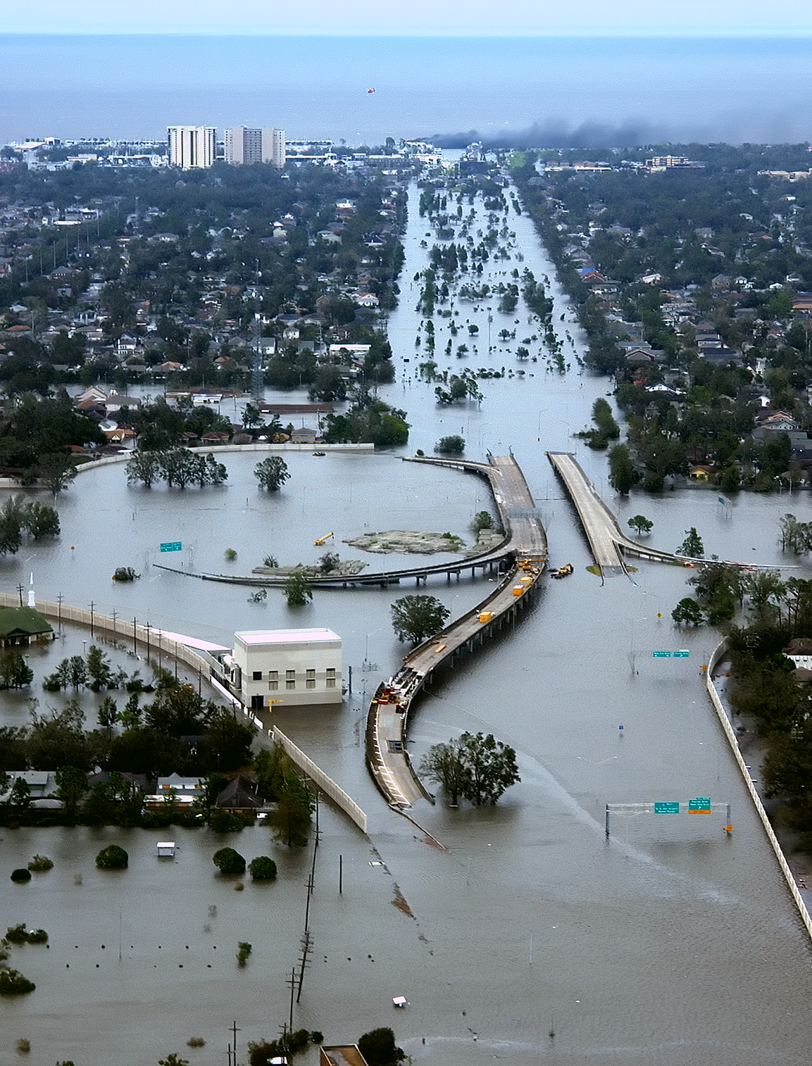
Exactly 12 years ago: Hurricane Katrina flooded the I-10/I-610 interchange in northwest New Orleans and Metairie, LA. (Wikimedia/AP Photo/U.S. Coast Guard, Petty Officer 2nd Class Kyle Niemi)
I'm sure I can't be the only person who's been getting an uneasy feeling of "déjà vu all over again" (thanks, Yogi!) when listening to or reading about Harvey's devastation. We heard the same basic stories of inadequate infrastructure, inadequate shelter facilities, stretched-thin rescue services, and unequal impacts to richer and poorer communities (I'll give you one guess who's getting hit worse) during and after Hurricane Katrina in New Orleans, and Hurricane Sandy in New York/New Jersey.
A washed-out bridge, and then some: Mantoloking, NJ, October 31, 2012, after Hurricane Sandy. (Mario Tama/Getty Images)
Massive storms, floods, droughts, fires, and other disasters may be touted in the headlines as 100-year, 50-year, or even 1,000-year events. But seriously: How many years in a row can we have "100-year" events before it begins to dawn on even the slowest among us that things are changing?
It turns out that it actually is possible to plan, build, and prepare for even rather extreme disasters, but it takes forethought. It takes community acceptance that it's necessary.
IMAGES: I first found the YouTube video of interspersed "before" and "flooded" views of the Buffalo Bayou in Houston on BoingBoing (the article compiles several more before-and-after images that are quite startling). According to streetreporter, who posted it on YouTube, "The still images are from unknown people shared by a French twitter user. I only made the dissolve to show perspective, which is transformative." Many thanks to Wikimedia, for the 2005 photo of the Hurricane Katrina flooding at the I-10/I-610 interchange in northwest New Orleans and Metairie, LA, an AP Photo/U.S. Coast Guard, Petty Officer 2nd Class Kyle Niemi. Equal thanks go to Slate and Mario Tama of Getty Images for the photo from Hurricane Sandy. I also thank Abode Home Group's "Restoration" page for the Fire/Flood/Storm composite image.
Three major signals of climate change's onset are increased rates and ferocity of fires, deepening drought, and increasingly violent storms. Today's image focuses on storms.
Thunderstorm with internal lightning over Graham, TX, by Mike Mazeul II
I could look at these all day, but a little reminder may be in order that gorgeous clouds can contain devastating downpours, tornadoes, and/or hurricanes that can do millions of dollars' worth of damages in just a short time. Havoc such as that shown in these photos:
This is what we denizens of Tornado Alley call "a real toad-strangler." This storm hit the San Fernando Valley in February 2017.
The website didn't give a location or date for this photo, but I hope that truck had water wings!
Stormy surf at Porthcawl Harbor, South Wales, in 2014. (photo: PA/Mirror)
A man in Northern Ireland excavates his sheep from a snowdrift in 2014.
Dramatic flooding resulted in 2015 from Tropical Storm Etau in Japan.
2016 flooding and mudslides in Victory, WI made for some arduous cleanup afterwards.
One thing's clear: we'd better batten down the hatches--and make sure we have an emergency plan. Unfortunately, we never know when we'll be caught up in the next disaster. IMAGES: Many thanks to Mike Mezeul II and The Daily Mail for the gorgeous "storm porn" series at the top. I also am grateful to Climate 101 with Jason, for the San Fernando Valley storm photo by David McNew/Getty Images, to Insurance Advocate for the hurricane-swamping-the-road photo with the pickup truck, to the Mirror for the stormy surf South Welsh photo from 2014, and to the BBC for the photo of the Northern Irishman excavating his sheep from a snowdrift the same year. Many thanks to Young Independent for the Tropical Storm Etau image, and to WXOW Channel 19 of LaCrosse, WI for the mudslide photo.